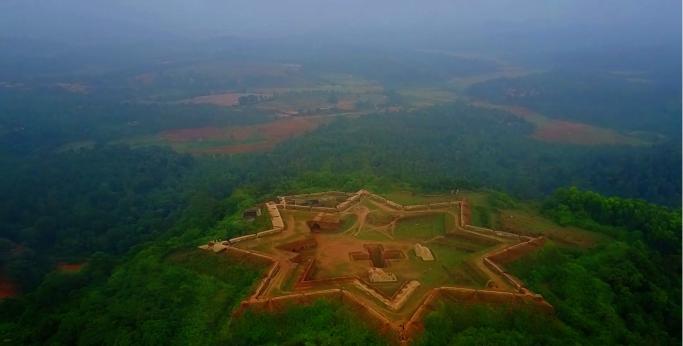
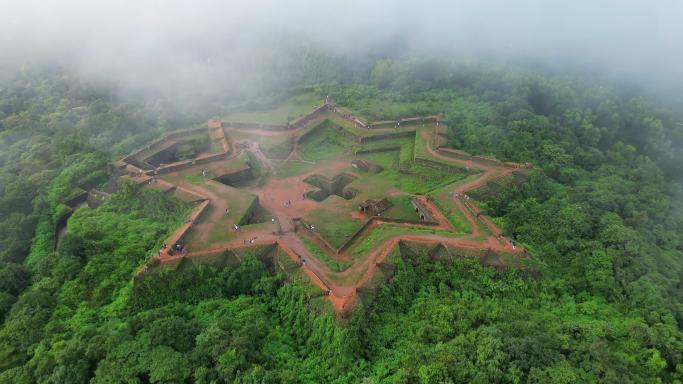
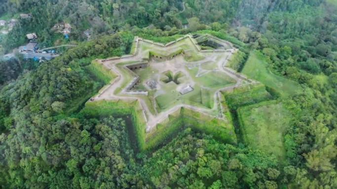
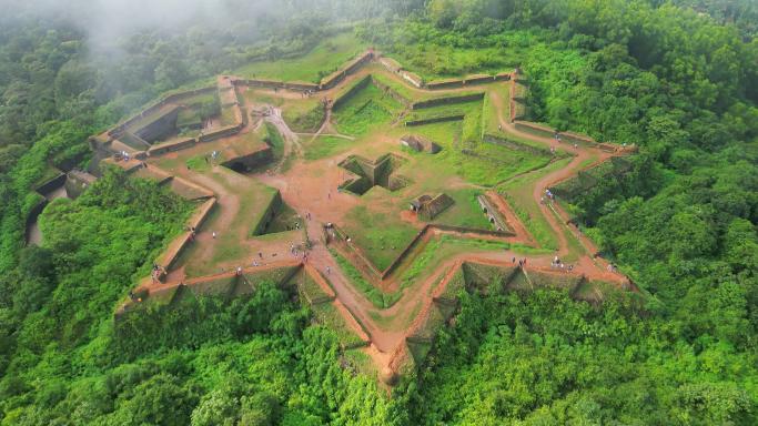
If you’ve ever stood on a fortress’s rampart and thought that the walls would tell tales from long-ago times, then you haven’t visited Manjarabad Fort yet. It’s located just outside Sakleshpur, Karnataka. It’s not your typical circular stone fortress, but rather a mathematical marvel, tactical masterpiece, and amongst the modern traveller, it’s one of the most photographed locations in the Western Ghats.
As a travel enthusiast who has climbed these 252 steps in everything from the scorching April sun to the misty embrace of July, I’ve put together this comprehensive guide. Here is everything you need to know about the “Star of the Western Ghats.”
The “Experience” Factor: What It’s Really Like
To understand Manjarabad, you have to understand the Mist.
“Manjarabad” derives from the Kannada word “Manju,” meaning “mist” or “fog.” If one goes to this site in the rainy season during June to September, it is an incredible experience. When one starts at the base of the fort near the NH-75 roadway, the climate is humid and there is the smell of damp coffee hulls from the various coffee plantations. As you go up the granite steps, the temperature drops by the time you arrive at the main entrance to the fort, the “Abode of Fog,” and the visibility drops to around 5 ft, making the fort look like a ghost ship floating in a sea of white.
The Climb
- The Stairs: There are approximately 250 steps. They are well-maintained but can be slippery during the rains.
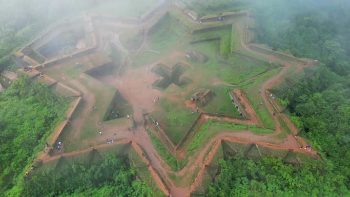
- The Sensation: Reaching the top feels like stepping onto a giant’s compass. The symmetry of the star shape is so perfect that it feels intentional and grounding.
Technical Expertise – Fort Architecture of the Vauban School of Engineering
According to engineering history, Manjarabad Fort is an anomaly in the timeline of Indian Fortification. While height and large boulders were a typical feature of Indian Forts (Chitradurga, Gwalior, etc.), the architecture of Manjarabad relied on geometry.
The French Connection – Building Fort for Tipu Sultan
In 1792 AD, Tipu Sultan used his alliance with the French to fortify his frontier against the British and Kodavas.
Why use a Star Shape to Fortify?
Eliminate Dead Zones: When enemy troops reach a wall of a square fort, they will be out of sight of defenders at the top may therefore be in danger if they attempt to lean over the top of the wall to see them. In contrast, when the enemy is at any of the points of a star fort, defenders may see and fire at the enemy troops at that point and also from adjacent points. This is possible through the crossfire created by each adjacent point.
Deflect Artillery: The fort walls sloping surfaces allow cannon fire to deflect off them rather than have all of the energy absorbed by the fort walls, thus greatly increasing the difficulty of breaching the fort.
Inside the Walls: A Layout for Survival
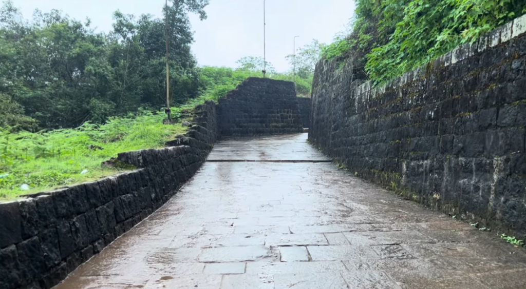
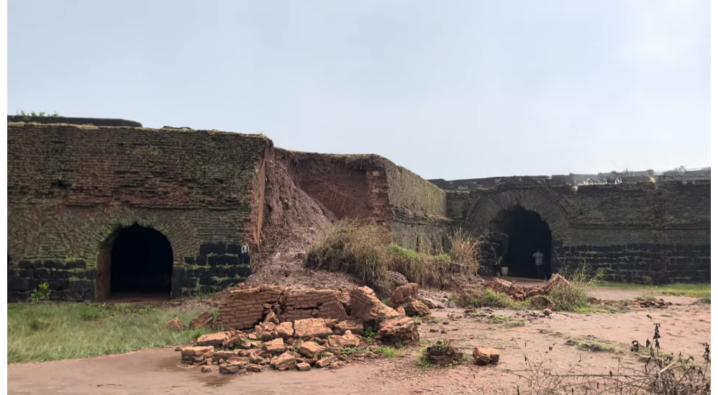
The fort was designed for a garrison of soldiers to survive a long-term siege. When you walk through the arched entrance, look for these specific features:
The Central Water Tank
In the exact center of the fort lies a cross-shaped rainwater harvesting tank. Even in the height of summer, this tank rarely goes dry. It is a testament to the sophisticated plumbing of the 18th century.
Expert Tip: The acoustics near the tank are incredible. If you stand at the edge and speak softly, your voice carries across the water to the other side.
The Underground “Magazines”
Along the inner perimeter, you will find arched rooms. These weren’t just for soldiers to sleep in; they were gunpowder magazines. They are built deep into the earth to keep the powder cool and dry—a technical necessity in the humid climate of the Western Ghats.
The Legend of the Tunnel
The tale of the tunnel is widespread throughout the area. There are many stories claiming a connection between the two cities. While I personally have been able to explore many of the so-called “blocked” entrances, current structural reviews seem to indicate that they are probably just underground drainage systems or a means of escaping down to the bottom of the hill and not the 100-kilometer-long underground tunnel that many claim.
Authoritative Travel Data (2026 Update)
To ensure your trip is seamless, here is the verified logistical data for this year.
| Feature | Information |
| Location | Donigal, Sakleshpur (6 km from town center) |
| Elevation | 3,241 feet (988 meters) |
| Built In | 1792 AD |
| Entry Fee | Free (Government Protected Monument) |
| Best Time | 7:00 AM (for the mist) or 4:30 PM (for the sunset) |
How to Reach
- By Road: It is a 4-hour drive from Bengaluru (220 km) via the Hassan highway. The roads are excellent 4-lane highways until you hit the Sakleshpur bypass.
- By Train: The “Green Route” train from Bengaluru to Sakleshpur is one of India’s most scenic rail journeys. From the station, a 15-minute auto-rickshaw ride will take you to the fort base.
Building Trust: Safety and Ethics
Being a responsible traveler is very important as this site grows more popular.
Trash: There are no trash cans in the fort itself. You must pack in all of your trash, and pack all of your trash out. The local community is trying hard to keep the site plastic-free.
Rampart Safety: There are no railings on the ramparts. There is a significant drop (over 30 feet in some places). If travelling with small children please keep them away from the edges when the stones are wet (the moss makes it slippery).
Monkeys: The macaques at this site are very bold. Do not carry any food in an open bag or container, as the macaques will associate that sound with getting a snack.
Photography Guide: Getting a Shot of The Star
Drones are essential for taking those iconic “star” shots that travel blogs showcase. You can only see a couple of the stars from the ground at any given time.
Drone regulations – ensure you have a UIN (Unique Identification Number), and check local “No Fly Zone” updates. Most hobbyists can fly in the general area, but always check for nearby government buildings.
Golden Hour – The fort faces the sunset. Between 5 PM and 5:30 PM, you will catch the granite appearing to be a very deep orange, creating a beautiful contrast to the very dark green of the valley below the fort.
What are Other Sites Nearby? (The Sakleshpur Circuit)
You should not only visit the fort but also check out some of Sakleshpur’s hidden treasures:
- Bisle Ghat View Point – 45 km away…
Panoramic view with three ranges of mountains behind & in front of you…
- Hemavathi Backwaters – “Submerged church”…(Shettihalli Church)….will be submerged half way during rainy season.
- Abbi Valley…..great place to explore off-road…will be majority of hidden waterfalls located within private farmland.